Log in
All resources
Create a design
4,774 Free Images of Atlas Map
copper engraving print
joan blaeu
british library
1667 maps
gemeente atlas van nederland - south holland
1860s maps of south holland
maps from university of amsterdam special collections
atlas der neederlanden
copperplate print
special collections of the university of amsterdam
atlas maior, vol 7 (france i) - joan blaeu, 1667 - bl 114.h(star).7
1667 maps
atlas maior, vol 8 (france ii and switzerland) - joan blaeu, 1667 - bl 114.h(star).8
1667 maps
atlas maior, vol 4 (netherlands) - joan blaeu, 1667 - bl 114.h(star).4
1667 maps
old maps of koedijk
old maps of alkmaar
atlas schoemaker-zeeland
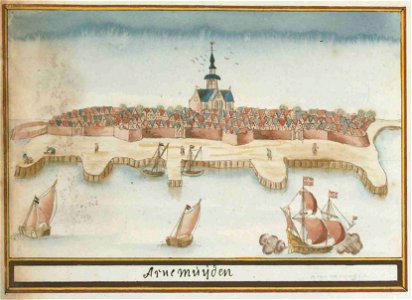
old maps of arnemuiden
siege of bredevoort 1597
old maps of bredevoort
18th-century maps of bohemia
grosser deutscher atlas
daniel friedrich sotzmann
grosser deutscher atlas
maps by willem and johannes blaeu
17th-century maps of france
old maps of north rhine-westphalia
maps of the county of mark
coats of arms on maps
ships on maps
gemeente atlas van nederland - north holland
19th-century maps of amsterdam
atlas schoemaker-overijssel
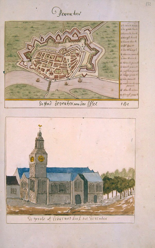
history of deventer
historisk atlas (stockholm, norstedt & söner, 1880)
maps showing 843
maps by willem and johannes blaeu
old maps of westphalia
gemeente atlas van nederland - south holland
19th-century maps of rotterdam
gemeente atlas van nederland - south holland
1860s maps of south holland
gemeente atlas van nederland - south holland
1860s maps of south holland
gemeente atlas van nederland - south holland
maps of heerjansdam
gemeente atlas van nederland - south holland
1860s maps of south holland
gemeente atlas van nederland - south holland
1860s maps of south holland
gemeente atlas van nederland - drenthe
drenthe
gemeente atlas van nederland - south holland
1860s maps of south holland
victor levasseur - maps of the world
coats of arms of switzerland
lordship of mechelen
1645 maps of belgium
maps of san juan, puerto rico
atlas blaeu-van der hem
gemeente atlas van nederland - south holland
19th-century maps of rotterdam
nieuwe en beknopte hand-atlas (1754)
18th-century maps of martinique
maps from university of amsterdam special collections
atlas der neederlanden
siege of zaltbommel 1599
1599 in the netherlands
gemeente atlas van nederland - south holland
maps of delfshaven
bologna ptolemy
1477 maps
gemeente atlas van nederland - limburg
19th-century maps of maastricht
atlas maior, vol 2 (sweden, russia, poland, eastern europe, and greece) - joan blaeu, 1667 - bl 114.h(star).2
magni ducatus lithuaniae
maps in the british museum
taddeo crivelli
maps showing history of the early middle ages
charles the bald
maps of the mali empire
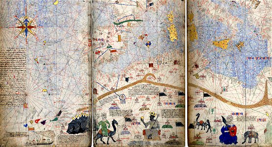
catalan atlas
maps by nicolaes visscher i
atlas van der hagen
gemeente atlas van nederland - south holland
1860s maps of south holland
gemeente atlas van nederland - south holland
maps of hendrik-ido-ambacht
gemeente atlas van nederland - south holland
1860s maps of south holland
gemeente atlas van nederland - south holland
1860s maps of south holland
old maps of the new kingdom of granada
maps by willem and johannes blaeu
gemeente atlas van nederland - north holland
old maps of edam
nieuwe en beknopte hand-atlas (1754)
old maps of curaçao
gemeente atlas van nederland - north holland
1860s maps of north holland
maps made in the 17th century
old maps of overijssel
old maps of north brabant
1645 maps of belgium
david rumsey historical map collection
andrew dury
emmerich am rhein in art
atlas beudeker
atlas ou representation du monde universel t. 1 (1633)
17th-century double hemisphere world maps
maps from university of amsterdam special collections
atlas der neederlanden
maps from university of amsterdam special collections
atlas der neederlanden
maps from university of amsterdam special collections
atlas der neederlanden
maps from university of amsterdam special collections
atlas der neederlanden
maps from university of amsterdam special collections
atlas der neederlanden
maps from university of amsterdam special collections
atlas der neederlanden
maps from university of amsterdam special collections
atlas der neederlanden
maps from university of amsterdam special collections
atlas der neederlanden
maps from university of amsterdam special collections
atlas der neederlanden
margraviate of moravia (1628-1782)
coats of arms on maps
catalan atlas, 1959 reproduction
abraham cresques
catalan atlas
issyk-kul
catalan atlas, 1959 reproduction
cartography of ukraine
maps of krimpenerwaard
atlas novus (blaeu)
kingdom of bohemia (1627-1740)
17th-century maps of bohemia
william smith (lexicographer)
maps of nineveh
victor levasseur - maps of france
old maps of meurthe (department)
atlas van der hagen (volume 3)
atlas van der hagen
old maps of deventer
atlas de wit 1698
old maps of krefeld
1645 in krefeld
maps in the library of congress
animals on maps
maps from university of amsterdam special collections
atlas der neederlanden
coats of arms on maps
atlas novus (blaeu)
maps by willem and johannes blaeu
1648 maps of africa
nieuwe en beknopte hand-atlas (1754)
18th-century maps of panama
nieuwe en beknopte hand-atlas (1754)
1754 maps of quebec
atlas maior, vol 8 (france ii and switzerland) - joan blaeu, 1667 - bl 114.h(star).8
1667 maps
atlas maior, vol 10 (spain and africa) - joan blaeu, 1667 - bl 114.h(star).10
1667 maps
atlas maior, vol 1 (northern europe, norway, and denmark) - joan blaeu, 1667 - bl 114.h(star).1
1667 maps
atlas maior, vol 2 (sweden, russia, poland, eastern europe, and greece) - joan blaeu, 1667 - bl 114.h(star).2
17th-century maps of hungary
atlas maior, vol 8 (france ii and switzerland) - joan blaeu, 1667 - bl 114.h(star).8
1667 maps
atlas maior, vol 7 (france i) - joan blaeu, 1667 - bl 114.h(star).7
1667 maps
atlas maior, vol 7 (france i) - joan blaeu, 1667 - bl 114.h(star).7
1667 maps
atlas maior, vol 1 (northern europe, norway, and denmark) - joan blaeu, 1667 - bl 114.h(star).1
1667 maps
atlas maior, vol 1 (northern europe, norway, and denmark) - joan blaeu, 1667 - bl 114.h(star).1
1667 maps
atlas maior, vol 7 (france i) - joan blaeu, 1667 - bl 114.h(star).7
1667 maps
atlas maior, vol 4 (netherlands) - joan blaeu, 1667 - bl 114.h(star).4
1667 maps
atlas maior, vol 4 (netherlands) - joan blaeu, 1667 - bl 114.h(star).4
1667 maps
atlas maior, vol 9 (italy) - joan blaeu, 1667 - bl 114.h(star).9
1667 maps of italy
atlas maior, vol 1 (northern europe, norway, and denmark) - joan blaeu, 1667 - bl 114.h(star).1
1667 maps
atlas maior, vol 9 (italy) - joan blaeu, 1667 - bl 114.h(star).9
1667 maps of italy
atlas maior, vol 1 (northern europe, norway, and denmark) - joan blaeu, 1667 - bl 114.h(star).1
1667 maps
atlas maior, vol 8 (france ii and switzerland) - joan blaeu, 1667 - bl 114.h(star).8
1667 maps
atlas maior, vol 4 (netherlands) - joan blaeu, 1667 - bl 114.h(star).4
1667 maps
atlas maior, vol 4 (netherlands) - joan blaeu, 1667 - bl 114.h(star).4
1667 maps
atlas maior, vol 8 (france ii and switzerland) - joan blaeu, 1667 - bl 114.h(star).8
1667 maps
atlas maior, vol 1 (northern europe, norway, and denmark) - joan blaeu, 1667 - bl 114.h(star).1
1667 maps
atlas maior, vol 9 (italy) - joan blaeu, 1667 - bl 114.h(star).9
1667 maps of italy
atlas maior, vol 1 (northern europe, norway, and denmark) - joan blaeu, 1667 - bl 114.h(star).1
1667 maps
1001 - 1100 of 4,774
Next page
/ 48